GEOANIMATOR JOURNAL
Google Map Animation: Make a Map Video on Android
Want a Google map animation without desktop software? See your options, then build a map video on Android with GeoAnimator and export 16:9, 9:16 or 1:1.

In this article11 sections
- 01What does Google map animation actually mean?
- 02What are your options for animating a map?
- 03How do I make a Google map animation on Android?
- 04Can I do a Google map animation for free?
- 05What about animating a route?
- 06Plan a storyboard before you build
- 07Mistakes that make map clips feel amateur
- 08Framing for different platforms
- 09Pacing, labels and sound
- 10Which approach fits the clip you have in mind?
- 11Frequently asked questions
Search for a Google map animation and you land on a mix of things: Google Earth tutorials, desktop editor walkthroughs, route animations built in 3D software. They all promise a moving map, yet they ask for very different amounts of setup. Some need a computer and a weekend.
If your goal is a short clip of countries lighting up and a camera gliding between them, an Android phone is enough. This post sorts out what people usually mean by the phrase, then shows a full build in GeoAnimator, an Android map animation app. It is not made by Google and does not use Google's tools.
What does Google map animation actually mean?
People use the phrase for three different jobs. The first is animating a route, such as a line that draws from one city to another. The second is a cinematic flyover of terrain or a city. The third is an explainer, where countries or regions highlight in sequence while someone talks.
The jobs need different tools, so it pays to name yours before you start. A flyover needs 3D imagery. A route needs path drawing. An explainer needs highlights, labels and a camera, and that is the one that fits on a phone without any fuss.
Pick one.
This post is mostly about the third job, with a pointer to the second where it applies.
What are your options for animating a map?
You can animate a map with a desktop video editor and plugins, a 3D tool, a browser-based animation service or a phone app. Desktop and 3D tools give the most control and the steepest learning curve. Phone apps trade some of that control for speed, and you can finish a clip in one sitting.
Google's own tools are sometimes part of the workflow, usually as a source of imagery or a place to plan a route before animating it elsewhere. Their features change, so check Google's current pages before you rely on any one of them.
If you are comparing editors in general, picking a map animation maker goes through what to look for. And if you are coming from desktop software, map animation without After Effects shows the phone-first alternative for the same job.
How do I make a Google map animation on Android?
To animate a map on Android, install a map animation app, search for the places to feature, highlight them, set a reveal, add camera keyframes on a timeline and export. GeoAnimator does all of that in one editor, and the finished video saves to your phone ready to upload.
A full build in GeoAnimator
Install GeoAnimator from Google Play and start a project.
Search for your first country or region and highlight it.
Choose a reveal: Fade, Flood, Wipe or Chase.
Open the timeline and set a camera keyframe on the whole map, then another zoomed on your first highlight.
Pick a hold (Push, Drift or Orbit) for the pause, and a transition (Orbit, Arc or Bounce) into the next place.
Repeat for each place, then add text layers for names or a one-line fact.
Choose 16:9, 9:16 or 1:1, export, and watch the result once before posting.
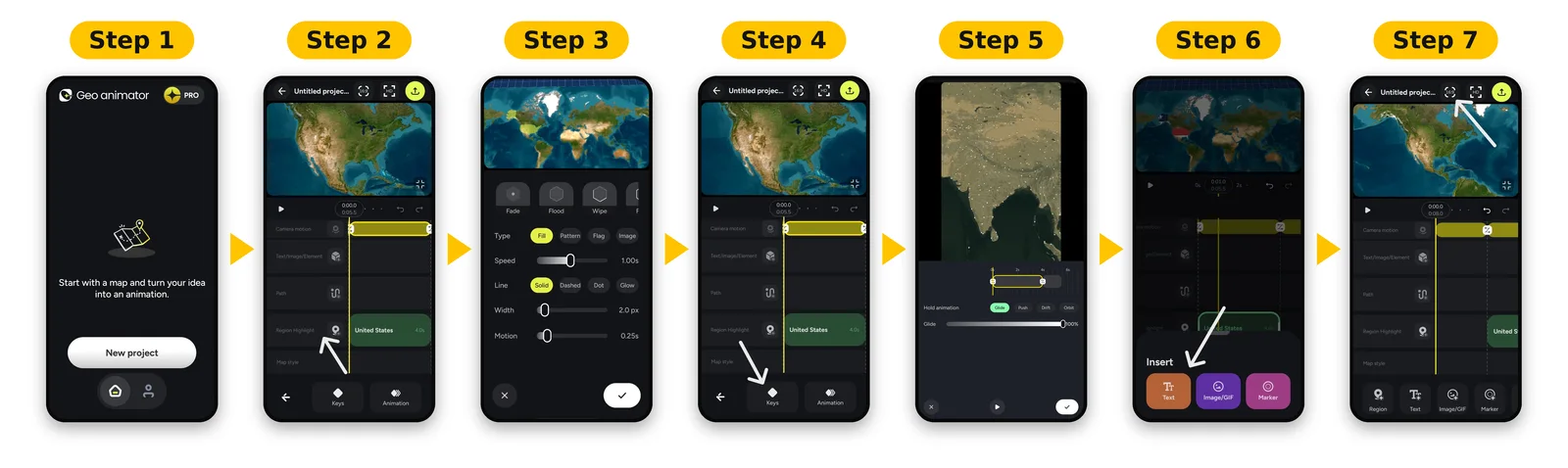
The free version covers this flow. Pro removes the watermark and unlocks all map styles.
Can I do a Google map animation for free?
Yes, within limits. GeoAnimator is free to download and you can build and export a clip without paying, though the watermark stays until you move to Pro. Free options elsewhere tend to trade away something too: time, polish, a desktop install or export size.
Test with a short clip before you commit to any paid tier. Ten seconds is enough to see whether the camera moves and reveals match what you had in mind.
Short test, then decide.
What about animating a route?
If your clip is about travel, a line that draws between stops usually beats highlighted countries. That is a separate workflow with its own settings. Our walkthrough on adding routes to a map animation covers drawing the path and timing it.
You can also combine the two. Open on a highlighted country for context, then draw the route inside it. Keep each element on screen long enough to read before the next one arrives.
Plan a storyboard before you build
Sketch the clip on paper first. Write one line per place: where the camera goes, what highlights, what the label says. A 30-second video usually holds four or five lines.
Here is a sample storyboard for a clip about the Nordic countries. Open on a wide view of Europe. Highlight Norway with a Wipe from west to east and label it. Drift the camera to Sweden, Flood the fill, label it. Arc to Finland, Fade it in, label it. Finish on Denmark, hold, and pull back to the full region so viewers see all four together.
Ten minutes, tops.
Notice what the plan decides for you. The order follows geography, so the camera never doubles back. Each place gets its own reveal only where the border shape suggests one, and the closing pull-back gives the whole clip a clear end.
Pick reveals with a reason
Do not use all four reveals in one video just because they exist. Pick one or two and repeat them. Consistency reads as design, and variety for its own sake reads as a demo reel.
Mistakes that make map clips feel amateur
The most common one is speed. New creators cram too many places into too little time, then wonder why the video feels frantic. Cut places before you speed up the camera.
Slow down.
Second comes label clutter. Three lines of text over a map hide the very thing you are pointing at. Keep the label short and place it where it does not cover the highlighted area.
Third, forgetting the ending. A clip that stops mid-move feels unfinished. Hold the last frame for a second or two, ideally on a wide view that shows everything you covered.
Last, skipping the phone test. A label that looks fine in the editor can be unreadable at normal viewing distance. Export, hold the phone at arm's length and watch it once through before you post.
Fact-check borders and names
Maps look authoritative, so errors travel. If a region is disputed, label it the way a reputable atlas does and keep the wording neutral.
Framing for different platforms
The export shape changes how you frame the map, so decide it before placing any keyframes. A zoom that looks right in 16:9 can crop a country awkwardly in 9:16.
16:9 suits YouTube and slides, where a wide regional view fills the frame.
9:16 suits Reels, Shorts and TikTok, where tall countries and long coastlines work best.
1:1 suits feed posts and compact subjects such as one country or an island group.
Posting the same story twice? Export twice and check the labels each time, because text sitting at the edge of a wide frame can fall off a square one.
Pacing, labels and sound
One rule fixes most weak map clips: give each place about five or six seconds. The camera needs time to arrive, the reveal needs time to play, and the label needs time to be read on a small screen.
Less text, more map.
Keep labels short. A place name and, at most, one fact. If you need more words than that, narrate them instead and let the map stay clean.
For sound, record the voiceover first and build the timeline against it, so each highlight lands on the word that names it. Music can go in last; adding music to a map animation covers sources and volume. Read the GeoAnimator journal for more clip ideas once this one is out.
Which approach fits the clip you have in mind?
The right approach is the one that matches your clip: a desktop editor for fine control over long projects, a 3D tool for cinematic flyovers, and a phone app for highlight explainers and quick social posts. Compare them on cost in time as much as on features, because a clip you never finish helps nobody.
| Approach | Best for | Cost in time |
|---|---|---|
| Desktop editor with plugins | Fine control, long projects | High |
| 3D tool | Cinematic flyovers | Very high |
| Phone app (GeoAnimator, Android) | Highlight explainers, quick social clips | Low |
For the broader how-to on phone-made clips, see map animations for video, and the GeoAnimator homepage lists what the app includes.
Frequently asked questions
What is a Google map animation?
It usually means a video where a map moves: a route draws, a camera flies over terrain or countries highlight in sequence. The phrase is not one product, so decide which of those three you want before choosing a tool.
Is there a Google map animation app for Android?
GeoAnimator is an Android app that makes map animations: highlights, camera keyframes, text and exports in 16:9, 9:16 or 1:1. It is made by Lascade, not by Google.
Can I make a Google map animation online for free?
Free options exist, though each trades something away. GeoAnimator is free to download and export with a watermark, and Pro removes it. Note that it runs as an Android app, not in a browser.
What should a map animation storyboard include?
A one-line script per place, the order you will visit them, the reveal you will use for each and the text that appears with it. Write that before opening any app. It takes ten minutes and saves an hour of reshuffling a timeline that has no logic yet.
Add a rough duration beside each line so the total length is visible before you build anything.
How long should a map animation be?
Thirty seconds suits most social posts, with five or six seconds per place. Longer explainers work if the voiceover carries interest, since a silent map with ten stops loses viewers quickly. Plan the script first, then trim after a test export.